ebenzunlimited
Moderator
Google's Mapping team goes offline with mobile Google Maps, shows off backpack-sized Street View contraptions, and wows with new 3D fly-over technology

Google announced Wednesday that its mobile version of Google Maps is going offline, Street View is going off road with a new backpack-sized camera, and Google Earth will soon be serving up eye-popping new 3D imagery that you'll be able to "fly" above.
News of the Google Earth and Maps upgrades come a week before Apple is expected to dump Google as its default mapping technology on its iOS mobile platform. In a world where location-based services are becoming more popular and lucrative this is bad news for Google. Perhaps Google's intent was to show Apple what it was going to miss. And it did.
Eye Popping 3D Fly Overs
Google?s Google Earth team has been working hard over the past year to add ?fly-over? capability to the product. Product manager Peter Birch demonstrated the new functionality by flying over some well known spots in San Francisco and viewing various angles of City Hall, Coit Tower and the Embarcedero.
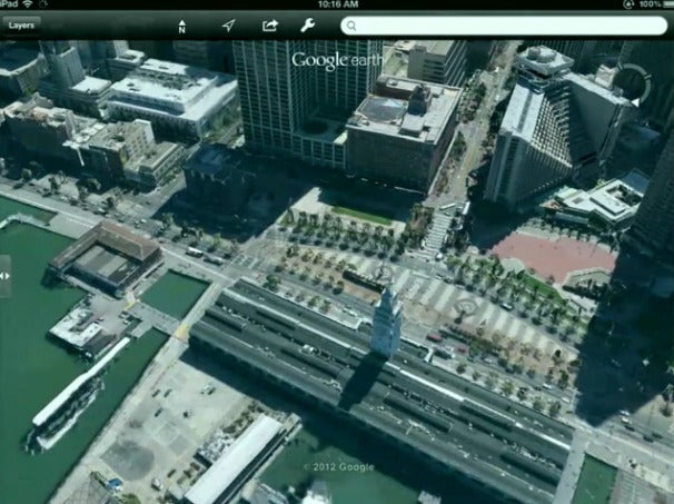
Google says it has contracted a fleet of small airplanes equipped with the Google Earth cameras. The planes fly around tall buildings and other landmarks, and in strips over the city capturing thousands of 3D images of different angles of every object and every piece of landscape.
Then through an automated process called Stereophotogamitry, a bank of computers uses complicated algorithms to review all the images captured by the planes. The best images for each tiny section of each object are chosen, then fitted together to form a complete 3D image. And there are many such 3D images for each building or landmark, covering all the angles one would see if he flew around it in an airplane.
The new fly-over capability will launch for a small set of cities ?in the next few weeks,? Google says
Street View Trekker

Google?s Street View is getting some new tricks, too. Luc Vincent, Google?s Street View engineering director was here to a new way Street View cameras will be going off-road to capture images. It unveiled a backpack-sized Street View camera that weighs 40-lbs and that people can wear and capture 360-degree images anyplace they can hike.
The Trekker is meant to compliment existing off road Street View cameras such as its Google trike.
Going Offline with Google Mobile Maps
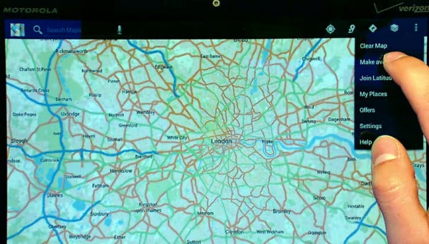
And finally, after many requests from users, Google is making mobile Google Maps usable even when you have no access to Wi-Fi or cellular signal. You just select a section of a map that he will need offline before they leave home. Then map then downloads, and when you arrive at the place where you know you?ll be offline, the Map will work in a very similar way to how it works when connected.
The map will work with your GPS signal to locate where you are, but you won?t be able to zoom down to Street View level. This capability will be available in the next few weeks on Android, but not on iOS. The service will become available in the next few weeks, the company says.
Google says it has now collected more than 20 petabytes of Street View imagery, and that 75 percent of all people in world can now see their house in a high definition graphic on Google Maps.
But Wednesday?s announcements come with some bad news (for Google) from Apple. The <a href="http://www.nasdaq.com/article/wsj-apple-likely-to-ditch-google-maps-in-upgraded-mobile-operating-system-20120606-00711">Wall Street Journal is reporting</a> it has confirmed reports that it will ditch Google Maps for its own mapping app later this year. Apple will launch its own mapping service as part of it new iOS6 operating system for iPhones and iPads, the Journal reports. Today, Google Maps is the default map service in iPhone and iPad.
Google announced Wednesday that its mobile version of Google Maps is going offline, Street View is going off road with a new backpack-sized camera, and Google Earth will soon be serving up eye-popping new 3D imagery that you'll be able to "fly" above.
News of the Google Earth and Maps upgrades come a week before Apple is expected to dump Google as its default mapping technology on its iOS mobile platform. In a world where location-based services are becoming more popular and lucrative this is bad news for Google. Perhaps Google's intent was to show Apple what it was going to miss. And it did.
Eye Popping 3D Fly Overs
Google?s Google Earth team has been working hard over the past year to add ?fly-over? capability to the product. Product manager Peter Birch demonstrated the new functionality by flying over some well known spots in San Francisco and viewing various angles of City Hall, Coit Tower and the Embarcedero.
Google says it has contracted a fleet of small airplanes equipped with the Google Earth cameras. The planes fly around tall buildings and other landmarks, and in strips over the city capturing thousands of 3D images of different angles of every object and every piece of landscape.
Then through an automated process called Stereophotogamitry, a bank of computers uses complicated algorithms to review all the images captured by the planes. The best images for each tiny section of each object are chosen, then fitted together to form a complete 3D image. And there are many such 3D images for each building or landmark, covering all the angles one would see if he flew around it in an airplane.
The new fly-over capability will launch for a small set of cities ?in the next few weeks,? Google says
Code:
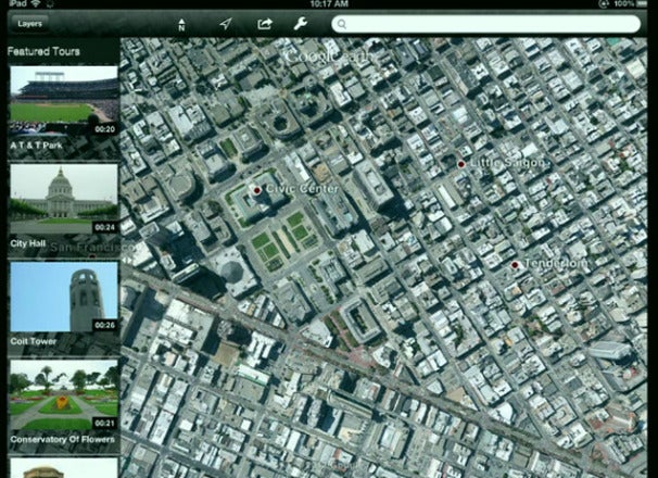
Image shows Google Guides, a service that allows you to pick a point of interest (left) and then Google will "fly" over that areaGoogle?s Street View is getting some new tricks, too. Luc Vincent, Google?s Street View engineering director was here to a new way Street View cameras will be going off-road to capture images. It unveiled a backpack-sized Street View camera that weighs 40-lbs and that people can wear and capture 360-degree images anyplace they can hike.
The Trekker is meant to compliment existing off road Street View cameras such as its Google trike.
Going Offline with Google Mobile Maps
And finally, after many requests from users, Google is making mobile Google Maps usable even when you have no access to Wi-Fi or cellular signal. You just select a section of a map that he will need offline before they leave home. Then map then downloads, and when you arrive at the place where you know you?ll be offline, the Map will work in a very similar way to how it works when connected.
Code:
To make a Google Map available offline select the area you want to save offline, choose "Make Available Offline" from the drop down menu, and download.
Code:
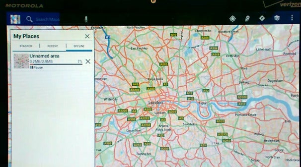
As you can see above, downloading a map of London required just under 3MB of free space on a mobile device.But Wednesday?s announcements come with some bad news (for Google) from Apple. The <a href="http://www.nasdaq.com/article/wsj-apple-likely-to-ditch-google-maps-in-upgraded-mobile-operating-system-20120606-00711">Wall Street Journal is reporting</a> it has confirmed reports that it will ditch Google Maps for its own mapping app later this year. Apple will launch its own mapping service as part of it new iOS6 operating system for iPhones and iPads, the Journal reports. Today, Google Maps is the default map service in iPhone and iPad.